Belgian Research Station Antarctica
Background information
prepared & maintained by F. Pattyn @ ULB

|
Belgian Research Station AntarcticaBackground informationprepared & maintained by F. Pattyn @ ULB |
|
Following the decision of the Council of Ministers, held on the 6th of February 2004, a new Belgian research station will be set up in the Sør Rondane Mountains, Dronning Maud Land, Antarctica. The coordination of the conception and prefabrication of the base by private companies - foreseen between 2004 and 2007 - has been confided to Alain Hubert of the International Polar Foundation. The construction and inauguration of the base is foreseen in 2007-2008, at the occasion of the fourth International Polar Year (IPY). The maintenance and functioning of the base will be coordinated by the Federal Science Policy.
More information on the Antarctic Research Station Project as well as the construction of the base can be found on the website of the International Polar Foundation.
A first site survey expedition was carried out during November-December 2004 to determine a precise site to build this scientific station and to perform the baseline field-work at this site. On the basis of a preliminary analysis, eight sites were selected as possible location for the new base. The pre-site survey then led to the selection of the ideal station-site should, which is situated on bare rock to have a longer lifetime compared to stations on snow or ice. A detailed topographic survey was carried out and an automatic weather station (AWS) was set up. Below flollows a brief description of the site and the area, as well as more information on the field survey and AWS.
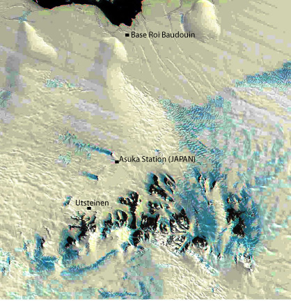
The proposed site of the Belgian station on Antarctica is situated 300 m North of Utsteinen nunatak, on a small relatively flat granite ridge, sticking out of the snow. The ridge – oriented in a more or less NS direction – is 700 m long and a few meters large and elevates 20 m above the surrounding snow surface in the accumulation zone. The position of the area is 71°57’ S and 23°20’ E. Utsteinen nunatak lies 60 km from the former Japanese Asuka station; 190 km S from Breid Bay, the edge of the ice shelf, 180 km S from the former Belgian Roi Baudouin base, and a few kilometres from the Sør Rondane range itself.
Utsteinen seemed from the beginning a promising base site for the following reasons:
Utsteinen nunatak is a few kilometres north of the Sør Rondane Mountains. This granite rock consists of two peaks and culminates at an elevation of 1800 m a.s.l. Around the nunatak a some blue ice fields extend with the presence of surficial lakes, at least frozen at the beginning of summer. The SE side of Utsteinen has a large wind scoop.
Although the north rim of Utsteinen is mostly devoid of mosses and algae, they are quite abundant on the nunatak itself. Here, also a few Snow Petrel couples (less than 10) breed on the steep slopes of the nunatak. The Antarctic Skua that visited our camp on a daily basis must have a nest site in the vicinity as well.
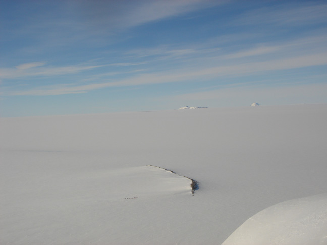

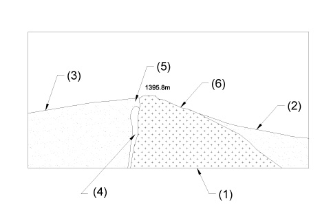
The outcrop of the proposed new station site is a northern extension of the Utsteinen Nunatak in the south (Van Autenboer and Loy, 1966). The outcrop, approx. 700 m long and 20-30 m wide, is predominantly composed of massive coarse-grained granite with minor xenolithic blocks of metamorphic rocks covering less than 10% of the outcrop. Exotic rocks and sediments (till and moraine) are negligible on the surface of the outcrop. In general granitic rocks tend to be easily weathered chemically and mechanically. However the granite in the present site is rather fresh suggesting recent (probably Holocene) exposure on surface. A set of joint system trending NNW and NE is dominant and the long and narrow outline of the outcrop is controlled by the NNW joint.
The granite is a part of the “Pingvinane granite” which is typically distributed in the Pingvinane Nunataks 10 km west of the site (Shiraishi et al., 1992). The granite is a typical alkali granite with coarse-grained equigranular texture. Mafic schlieren of 10-20 cm long are found in some places. The granite is composed mainly of K-feldspar (35-50 vol.%), quartz (20-45 vol.%), plagioclase (20-45 vol.%), hornblende and biotite (2-5 vol. %) with or without clinopyroxene (Li et al., 2003). Accessory minerals are Fe-Ti oxides, titanite, apatite and zircon. The Pingvinane granite generally has low magnetic values (3 to 8 10-4 SIU) corresponding to the ilmenite series (Shiraishi et al., 1992). The intrusive age of the granite is considered to be ~500 Ma estimated by the similar rock type in Pingvinane Nunataks. The granite contains xenolithic blocks and lenses up to several meters long in places. The boundary to the granite is sharp. They are quartz-feldspathic hornblende gneiss and amphibolite with banded and migmatitic structure.
Most of the granite along the ridge is relatively fresh and weathering only occurs over the top few centimetres. However, in some areas along the ridge the granite is more deeply weathered. These weathered zones can easily be observed from the three-dimensional view of the topography of the ridge as well, as they occur in these areas that are lying much lower. Here, the wind has weathered a large part of the rocks away. Due to the deeper weathering, the lower zones of the ridge can not support a construction without a lot of anchoring efforts. The building site is thus confined to the higher lying areas which have much better anchoring conditions.
Glaciological investigations were carried out by Belgian (1958-1967) and Japanese (1987-1991) field parties both on the ice shelf as in the mountains. They allowed among other things to estimate the total mass flux of ice through the mountain range (Van Autenboer and Decleir, 1974, 1978) and to map the subglacial topography of the central Sør Rondane (Pattyn and Decleir, 1995) but many parameters for a physical understanding of the glacier behaviour in the mountain range -as well as with respect to the adjacent ice shelf - are still unknown. This is even more so for the large and fast flowing ice streams contouring the damming mountain range, making the 20-30 degrees east sector one of the least known areas of the Antarctic ice sheet.
Since most of the ice flow coming from the polar plateau is blocked by the mountain range, many sheltered areas exists that are characterised by slow ice movements, as is the case with the proposed construction site. However, only a few measurements with respect to ice dynamics and mass balance have been carried out in the immediate vicinity of the Utsteinen site.
The table below lists accumulation rates and displacements measured between 2004 and 2005 for stakes set up close to the Utsteinen ridge (within 300 m). Since snow density measurements were not carried out, values are given in cm snow depth. Highest accumulation rates are found East and West from the ridge, around 45 cm/year (stakes I, II and IV). At the northern part, accumulation is half this value (20 cm/year), while in the South (stake V), ablation rules at a rate of approximately 10 cm/year. Here the snow layer is relatively thin and the stake lies in the proximity of a blue ice field.
| Stake nr | Accumulation (cm snow/year) | Displacement (cm/year) |
| I (West) | 42 | 5.5 |
| II (West) | 43.5 | 14.1 |
| III (North) | 24.5 | 8.7 |
| IV (East) | 47 | 26.2 |
| V (South) | -9 | 8 |
Minimum displacement is found to be 5 cm/year (stake I), maximum displacement amounts to 26 cm/year (stake IV). These low values indicate that the whole area around the ridge is stable and hardly influenced by the overall ice sheet motion.
Ice thickness measurements were carried out along an East-West transect across the ridge. Ice thickness rapidly increases to 200 m in depth away from the ridge over a horizontal distance of 500 m. Furthermore, the ridge is asymmetric in shape. The western part is deeper than the eastern side at a same distance from the ridge. Such asymmetry is also observed near the ridge extending from Utsteinen Nunatak. Further away from the nunataks previous Belgian measurements (Van Autenboer and Decleir, 1978) indicate ice thicknesses of more than 1000m and a subglacial bedrock close to or even below sea level.
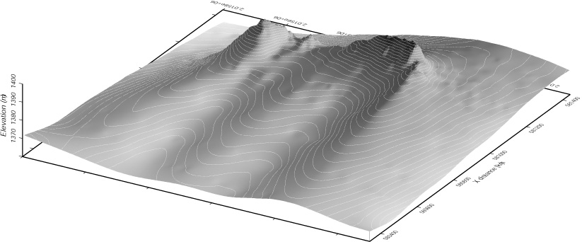
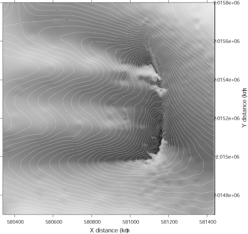
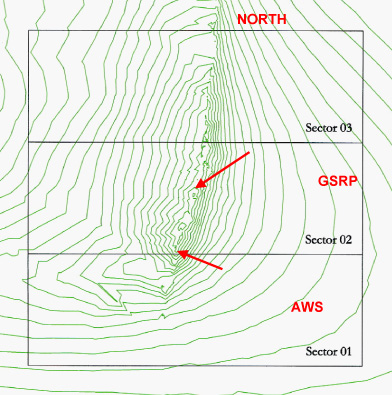
The whole northern rim of Utsteinen as well as the immediate surroundings were topographically mapped with a differential GPS system (D-GPS). Therefore, a reference system was set up on the highest spot of the southern part of the Utsteinen Northern rim (Figure 7). The geographic coordinates of this reference point are:
Latitude = 71° 57’ 1.15781” S
Longitude = 23° 20’ 48.72511” E
Elevation = 1397.4382 m
This reference point was clearly marked with red paint and a cairn is build on top of it at the end of the field season. In total, almost 3000 points were measured with D-GPS, which led to the construction of a detailed topographic map of the rim and its surroundings. These measurements will form the base for the construction of the station. A number of cross profiles will be analysed to study the effect of the katabatic wind in order to select the most suitable spot on the rim for the construction.
During the site survey an Automatic Weather Station (AWS) was set up on the southern part of the northern Utsteinen rim. The system was developed by Anderaa (Norway) and proved to be robust and reliable in polar and sub-polar areas. The AWS measures meteorological parameters, such as air temperature, wind speed and direction, atmospheric pressure, and sunshine duration. Apart from air temperature that is measured at an elevation of 1.5 m above the surface, all other measurements are made at 4 m above the rock surface. Measurements are done at 10 minute intervals and transmitted via an Argos satellite transmitter to Toulouse (France), from where data is send to Brussels. A backup solution is given by a data storage unit, that is capable of storing all data for at least a few years. The system is designed to remain operational for 2 years without maintenance (such as replacing the batteries).

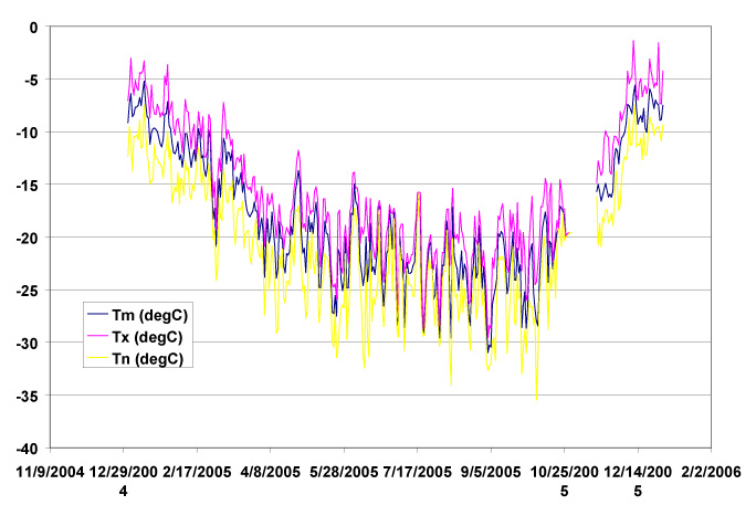
The temperature record from the AWS, installed during 2005 at the site of the new station, is analogous to the 1987-91 series from Asuka station, situated 55 km further north-east and 466 m lower in height. Average temperature amounts to – 18°C, varying between -8°C (December) and - 25°C (September). This implies that the daily maximum does not exceed zero in summer, while the daily minimum reaches - 36°C in winter. Although this temperature regime is relatively mild as compared to the lower lying Asuka Station and to the temperatures observed at Base Roi Baudouin (- 15 °C, close to sea level and 173 km further north), the yearly variation of the temperature curve shows already the typical coreless winter character of the more continental stations. It is characterized by a rapid drop in temperature in fall, a first minimum in May, a second (more important) minimum in August- September and a very steep rise towards the December-January maximum. This coreless winter results from the specific radiation conditions during the polar night. At the new site the sun stays permanently below the horizon from May 16 to July 28 (73 days) but some twilight remains around noon, even at Midwinter.

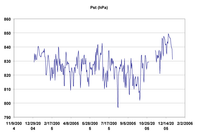
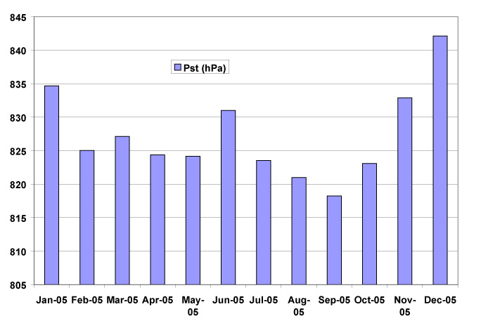
Atmospheric pressure variations at Utsteinen are relatively constant in time while oscillating around a mean value of 827 hPa, which underscores the fact that coastal cyclonic activity hardly influences the site. With exception of low pressure values in August and September, all variations are within 20 hPa. The yearly pressure curve lacks the double minima observed at most coastal stations.
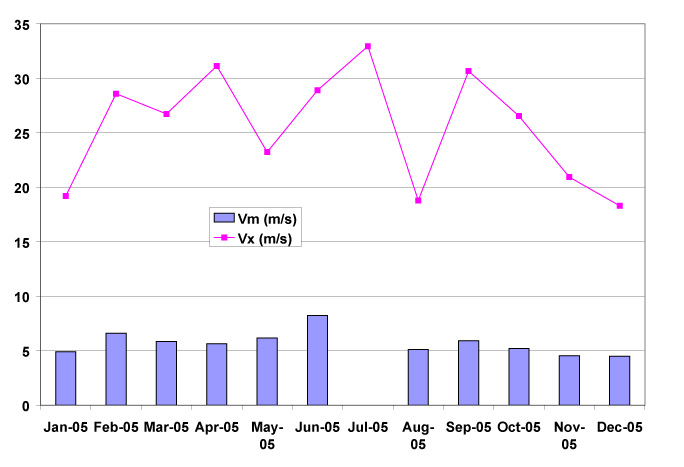
Utsteinen ridge benefits from the protection of the mountains and is, due to its position at the western side of the range, less influenced by high katabatic wind speeds. Nevertheless, the site is not over-protected as it protrudes northwards from the northern rim of nunataks and therefore benefits from a more constant wind flow that might be useful from an energetic point of view. The mean wind speed recorded at Utsteinen amounts to 6 m/s, which is half the mean wind speed recorded at Asuka Station, situated at 55 km to the Northeast. Mean summer wind speeds are around 4.5 m/s.
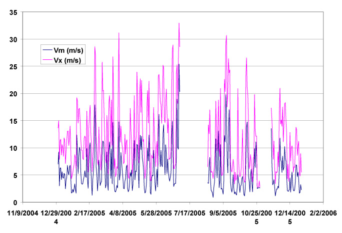
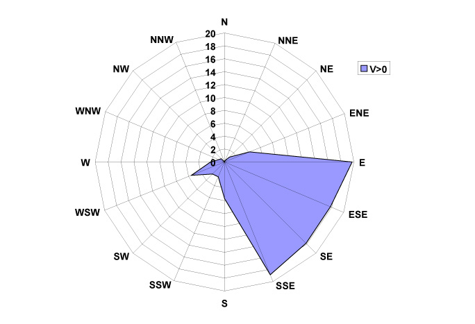
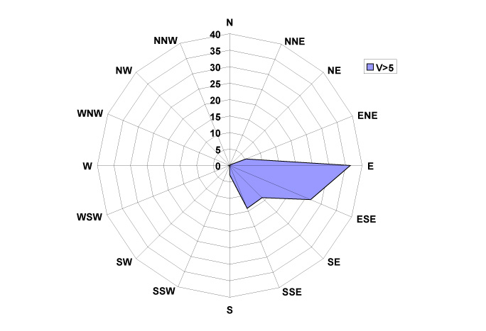
The main wind direction at Utsteinen is from the East, which is a katabatic wind regime coming from Jenningsbreen, one of the major outlet glaciers that cut through the range. Somewhat less frequent are winds from the SE direction, coming from Gunnestadbreen, the outlet glacier that lies closest to the site (Figure 6). The whole sector E to SSE accounts for more than 90% of winds at Utsteinen. More variable winds occur only at very low wind speeds, which shows that the katabatic wind regime is dominant. Higher wind speeds (> 15 m/s) mostly come form the E and ESE (80%) The nearly absence of a northerly component indicates that near the surface the climate is seldom reached by cyclones or air masses associated with the low pressure trough bordering Antarctica.
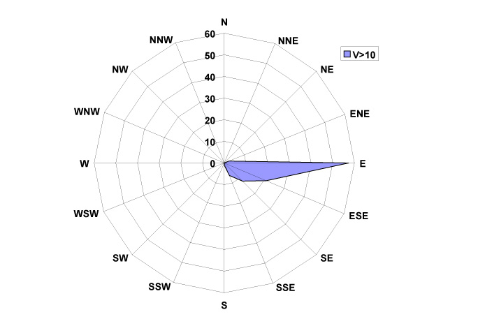
| Month | Pst (hPa) | Tm (degC) | Tx (degC) | Tn (degC) | Vm (m/s) | Vx (m/s) | D (deg) | D |
| Jan-05 | 834.7 | -8.7 | -3.0 | -16.8 | 4.9 | 19.2 | 99.5 | E |
| Feb-05 | 825.0 | -12.3 | -7.0 | -20.2 | 6.6 | 28.6 | 105.9 | ESE |
| Mar-05 | 827.1 | -15.5 | -7.2 | -24.1 | 5.8 | 26.7 | 123.1 | ESE |
| Apr-05 | 824.4 | -19.7 | -11.8 | -29.1 | 5.6 | 31.1 | 134.9 | SE |
| May-05 | 824.2 | -22.0 | -15.2 | -31.4 | 6.2 | 23.2 | 125.3 | SE |
| Jun-05 | 831.0 | -21.0 | -13.9 | -32.4 | 8.2 | 28.9 | 118.3 | ESE |
| Jul-05 | 823.5 | -23.2 | -15.8 | -30.8 | 32.9 | |||
| Aug-05 | 821.0 | -23.3 | -15.4 | -34.0 | 5.1 | 18.8 | 122.5 | ESE |
| Sep-05 | 818.2 | -24.4 | -16.8 | -33.0 | 5.9 | 30.7 | 113.2 | ESE |
| Oct-05 | 823.1 | -21.0 | -14.5 | -35.5 | 5.2 | 26.5 | 124.3 | SE |
| Nov-05 | 832.9 | -15.0 | -9.9 | -20.9 | 4.5 | 20.9 | 99.4 | E |
| Dec-05 | 842.1 | -8.4 | -1.4 | -17.5 | 4.5 | 18.3 | 98.1 | E |
| 2005 | 827.1 | -18.0 | -1.4 | -35.5 | 5.9 | 32.9 | 116.2 | ESE |
The one year record of the AWS at Utsteinen confirms what was already known from reports of field parties in the past, i.e. the relative mild climate (high temperature and low wind speed) of the Western part of the Sor Rondane, being optimal for field work in summertime. The yearly variation of the climatic elements on the other hand points towards the continental character of the climate. Seen the very few stations in the continental interior, the climatic record of the new Belgian station will contribute to a better understanding of the East Antarctic climate.
Biological research studies conducted in the Sør Rondane area are limited in number and studies at the construction site are non-existent.
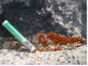
On the Utsteinen Ridge, only few Lichens were found. However they are quite abundant on the Nunatak itself. Three different species were detected, the same on both the Ridge and the Nunatak:
Published data on the breeding distribution of Antarctic (sea)birds in the Sør Rondane region are very limited. The vertebrate fauna in the vicinity of the station consists of birds only: Snow Petrel (Pagodroma nivea) and Antarctic Skua (Catharacta maccormicki).
There may be breeding colonies of Weddell seals (Leptonychotes wedellii) at various locations on the fast ice beside the ice front of Prinsesse Ragnhild Kyst. The offlying pack ice may support breeding populations of crabeater seal (Lobodon carcinophaga), Ross seal (Ophoroides rossii) and leopard seal (Hydrurga leptonyx). During summer, coastal waters may be visited by baleen whales and toothed whales. These whale species do not breed in the region but visit the area to feed.
There are no observations of Penguin rookeries at Breid Bay, neither during all the working years of the Roi Baudouin base nor during the Belare 2005 expedition.
Very few data on breeding sites of Snow Petrels in Antarctica are available from literature. In general, colony sizes seem to range from single pairs to an estimated 20.000 pairs. Snow Petrels breed amongst others on areas of exposed rock which may be as much as 300 km from the open sea during the breeding season. The colony farthest inland is in the Tottanfjella, Dronning Maud Land. The in literature recorded colony closest to the construction site is at Pingvinane (72°00’S, 25°00’E), with an inventory of about 100 breeding pairs in 1959-1961 (Croxall, 1995).
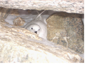
Some Snow Petrel couples are breeding on the steep slopes of the Utsteinen Nunatak, at a distance of about 1000 m from the new station construction site. It is extremely difficult to get an accurate census of breeding pairs. During the two site survey expeditions it was estimated that the small colony is made up of no more then 50 pairs. Most of the nests are high up the Nunatak slopes and thus difficult to access.
Snow Petrels return to the nest sites in November, the start of the station activities. One egg is laid in late November to mid-December and incubated for 41-49 days. The chick remains in the nest for an additional 7 weeks. Snow petrel chicks leave the nest in late February to mid-May, when the station is already abandoned.
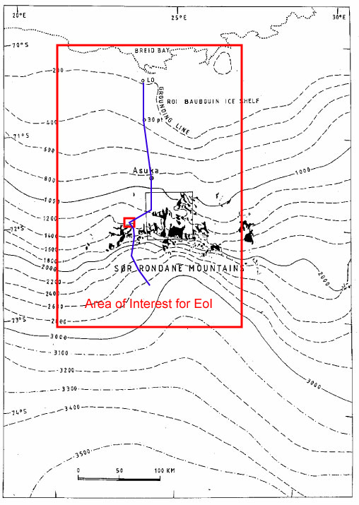
The area of interest for the Expression of Interest is limited to the mountain range itself, the polar plateau immediately south of the range and the coastal area in front of the range (Breid Bay, the ice shelf and grounding line region). The access routes to the north are following the line Asuka - 30pt - L0 (blue line shows safe access routes), which is the access route that JARE (Japanese Antarctic Research Expedition) used to access their Asuka station. At present, there is no known direct overland access route that crosses the grounding line to the ice shelf and Breid Bay. Access route to the south follows Gunnestandbreen, a major glacier cutting through the range tqaht is relatively free of crevasses.