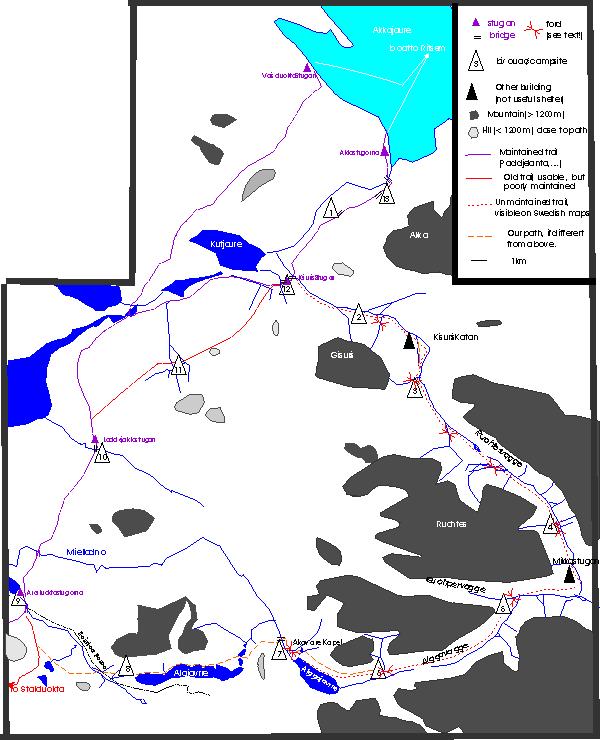
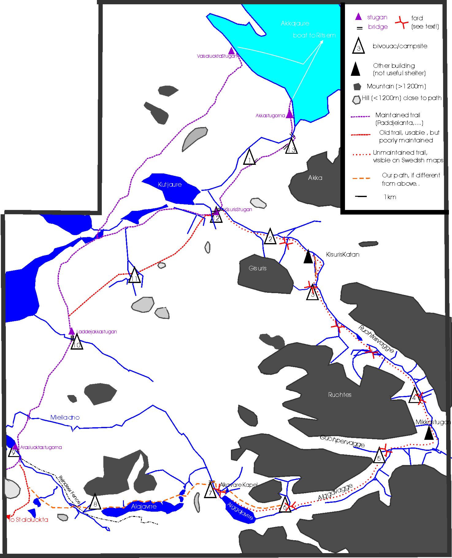
When clicking on images
in
this page, you get a larger version in an image viewer, BUT in the same
window -- it may be preferable to use the browser facilities to open
the link in another window or tab (right- or center-click, depending on your browser type) |

 |
July 21st
The weather is not yet stable when we leave the boat from Ritsem,
around 14h30
on the 21st. Our dislike of mosquitoes had brought us to plan to
camp
in heights, just beyond the spectacular bridge on the Vuojatädno.
But, our progress having been faster than expected thanks to the
clearing of the sky, we
decided to
push a
bit further. Our first camp was (surrounded by mosquitoes) in
JakkerJakka,
( for reference, we give the full coordinates as read from the
gps, but
the last two digits should not be trusted: Swedish Grid 1563108
7501090,
540m ), clearly a popular place since park authorities have gone
so
far as
to provide tables and even a toilet at the site. Glenn said that maybe, in the
swarm of mosquitoes in and around the camp, their might be architects and
builders grateful to humans for bringing them food every year. Slightly
downstream
along the
river, a number of appropriate tent sites can be found. Certainly
not
our
preferred camping place (we picked a place closer to our initial
choice
on the
way back), but it will do for the night.
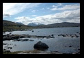
Pictures: JM dislikes the part of the Padjelanta trail between
Anjonjälme and the Kisuris hut. It tends to go "needlessly" up and
down, the summer hiker is likely to be pestered by mosquitoes, it is
perhaps a bit too "civilised", it lacks the drama of Sarek landscapes
and the strangeness of Tuottar further along the Padjelanta. Yet
beauty is present in the wood- and marshlands and also in glimpses of
the Sarek mountains and glaciers. It's worth stopping along the way to
enjoy the view. (more pictures at the end of the trip, as we had to go through this leg twice!)
|
 |
July 22nd
We started out with a very
clear
and promising day (our weather forecast
before
leaving Belgium was for a couple of rainy or cloudy days, with strong
wind, possible freezing, and maybe even snow. Swedish
travellers, however, had heard more comforting news). We quickly reach
the
entrance of
Sarek (a small path starts literally between the large boards
announcing the
meeting point of the 3 large parks). While we had lunch close to the
Sjnjuvtjudisjahka bridge, the sky darkened and rain started to seem
likely. After
some hesitation (should we continue our trip along the Padjelanta trail
and
return
through Sarek?), we chose to stick at least tentatively to our
preferred
itinerary, but to make a first camp in Sarek pretty close, leaving all
options
open for the next day.
We hiked with no
difficulty
to our first camp in Sarek this year, just
after
crossing the first river coming down Gisuris (easy crossing). We set up
camp
early, and sat through some rain. Our spirits were low: how long would
this weather last, we thought? (SG1563002 7494953, 620m)
Picture: We often saw piles of reindeer antlers like this one. We would
love to know if they have some purpose or meaning.
|


 |
July 23rd
We woke up in mixed
weather: light rain alternating with dry spells. We
managed
to fold our tents at a moment they were still dry. It was windy, rain
was
threatening,
and we needed our anoraks.
The second river was
easy
to cross, (SG 1565852 7494132, 730m) even if
we need
to walk upstream somewhat. Kathleen (her shoes are slightly lower than
JM's and
Glenn’s) prefers a "Teva-crossing". (our slang for the
painstaking task of removing boots, crossing in sandals,
and reversing the process !)
This part of the path is (as we
remembered) somewhat harder, with a
succession of
small rivulets and more marshy patches, which make progress a little
slower. By the time we reached Kisuriskatan
(SG 1567410 7493530 , 750m) - a ruined Sami hut made of branches and
beech bark
covered partially with earth -, the weather looked nicer, although
still
windy. We ate a warm lunch ( you never know if the weather will
make it as easy to
cook in the
evening) close to Kisuriskatan and set to move again. After the
hut, the
path
becomes more marshy, and we remember from 3 years ago that it
tends to
get lost in marshland along the main river. After crossing a small
river
(flowing S to N), we preferred to follow it on climbing ground in dry
terrain,
until meeting the main path (SG 1568233 7492665 , 790m) again
(the
larger
river, and the origin of the other, are very close at that point). With
windy
weather and taking into account the needed adaptation time, we chose
again an
early camp, just after the next river coming down (W-E) from Gisuris.
(Easy
crossing, but we prefer to take no chances and opt for the sandals).
Nice but cooler
evening. The night was dry and cold. (SG 1568245
7490480,
860m)
Pictures: The top picture shows the Sami hut mentioned as a ruin on the
map. In the middle, GAF and KBr are clearly hesitant about taking the
shortcut proposed by JM. KBr can confirm, however, that the shortcut
was both easier and more scenic than the marshy area we avoided.
The bottom picture shows a view from near the meeting point of
path and shortcut.
|


 |
July 24th
We had a very
pleasant walk up the valley of the
Nijakjådasj in this very sunny day. We
expected from previous experience a serious river crossing near the end
of this
valley, but with the dry weather this year, it proved easy. Other
walkers with
higher Swedish shoes could even dispense with the sandals when crossing!
Another large crossing
awaited us when entering the Ruohtesvagge, namely
the
very wide delta of the Smajla river. To our surprise, instead of
repeated
crossings over more than five hundred meters, only a single stream less than 10 meters wide but with
some power
subsisted. The crossing was easy, and
we pushed
on to set our next camp close to one branch of the Boasajagasj river.
(SG
1577083 7481051, 870m)
Pictures: Top to bottom:The valley that we are to follow opens before us,
JM and GAF crossing the single significant stream of what is
sometimes a wide delta.
KBr taking in the "drama" of
Sarek.
Ptarmigan among the rocks.
|


 |
July 25th
We started with fog coming
out of the Ruohtesvagge and light rain visible
in the
distance. This dat was quite cool (one of us puts on his gloves),
and by
the time we reached Mikkastugan (SG 1578880 7476939 , 820m) (closed, as
usual,
including now the hut where it used to be possible to dispose of some
refuse),
we sheltered downwind from the hut to prepare an early lunch. The river
was
spectacular as usual, despite its rather low flow when we crossed it at
the top
of the valley. Drizzle forced us to keep rain gear on while we
moved
through a short transition in the Guohpervagge to the beginning of the
Alggavagge. The path here is not always obvious, seeking its way
between the
steeper part of the mountain and the marshy part along the river. The
path we
followed is relatively high, but still has to force its way through low
vegetation (the low-lying willow brush can get annoying, but there are
usually man
or animal paths through it). With a heavy backpack, it can be tiring,
since it
forces us to constantly wind and step up or down because of rivulets or
small
outcrops. It became easier as we get a good view of Alggavagge.
Getting down
to the confluent, we crossed in several steps a river flowing from
Skarjatjahkka
into the Guohperjahka. A path led us directly to the side of the
Guohperjahka
just at its confluent with the river coming down (with a nice
waterfall) from
the Alggavagge. This is NOT the normal crossing point (although the
path is
clearly marked on both sides of the river!): the usual crossing point
is somewhat
higher
on the river. However, when water is low, it is worth checking, and
proves
easy (large flat stones, but quite some current). May we repeat that
this year was exceptional; the water is really low (10 cm below the
knee at the
deepest!).
We would definitely NOT try crossing here with high water! The weather
was clearing, but a cold wind was coming down the valleys, and we set
up camp
close to the waterfall. (SG 1574548 7475937, 890m).
Pictures: Top three: transiting through Guohpervagge on the way towards
Alggavagge. Bottom: our camp near the waterfall
(and in cold wind) at the end of a tedious transit between valleys.
|


µ |
July 26th
Nice weather and quick
progression in the easy Alggavagge. We felt
some
apprehension regarding the uncertain way out to Arasluokta (boats or a
bridge
on the Miellädno?), as we were now well beyond our mid-point in
the
Sarek.
In the afternoon, under hot sun, we
crossed the river flowing from the
Alkavare
before it flows into Alggajavrre. An easy crossing with sandals,
after
which we camped on the other side. (SG 1565887 7471111, 790m).
Pictures: (left and below) views and encounters in the beautiful Alggavagge.
     |


 |
July 27th
We had been warned that
the path from here to Alkavare Kapell could be
unpleasant (wet, with low willow brush) and that it is advisable to
choose a
"high" path. Such a path exists, but since the brush extends high on
the mountain, it still has to find its way between rivulets,
brush, and
outcrops. It is nevertheless definitely preferable to the "low" path (at least with our choice in favour
of
mountain
shoes).
The path leads directly to
the chapel , and under way
we see
one of the boats on a sand bank on the other side of the lake (probably
1 or 2
km before the lake flows into the Miellädno). No trace of a
second boat;
we will see later that it has been washed down into the Miellädno.
We see it
stranded close to the bridge.
We lunched at the chapel
(a
small stream just before the chapel provides
perfect
water). The weather is hot and the only shade is provided by the chapel
itself. We meet a couple who intend to camp near the chapel for a few
days, because there is going to be a church service on Sunday (the
congregation will be hiking to the chapel and the minister will come by
helicopter). They also showed us signs of previous mining activity in
the
area and tell us of how the miners did their mining in the winter,
throwing hot water on frozen stones to break them. Apparently the
conditions were very harsh and this was work that convicts were forced
to do.
We said goodbye to the couple and proceeded to the Miellädno. We
first walked downhill to the
Gainajjagasl, and
crossed it easily where it divides before flowing into the
Miellädno
(sandals
barely necessary). We found our way to the bridge, cutting across
varied
terrain. The re-installed bridge (the concrete foundation bears the
date 2002)
exists! Its foundations and the support cables look solid, but the
walkway has
been recovered from the previous bridge (probably larger, some remains
can be
seen on a hill slightly to the south, on the other side of the river),
and the
broken-down handrail has been replaced by a pair of steel cables with
plastic
sheathing. (SG 1559395 7473710, 737m)
We stop here for the day,
the weather stays sunny - almost too much so:
this
year we were constantly bothered by mosquitoes as soon as the
wind
dropped.
We never had this experience before at 600 m of altitude or higher.
Another
symptom:
while crossing Sarek (we are now technically no longer in Sarek, but on
the
Padjelanta) we saw only 3 reindeer, resting on a snow patch. Taking
pictures was difficult for they were fast and easily scared off. On our
previous
trip we saw many more, in cooler weather. It seems they had taken
refuge high
in the mountains and glaciers.
Pictures: from top::
Trudging through the brush
nearing the
end of the Alggavagge
Alggajavvre, the lake at the end of
the Alggavagge.
The Alkavare chapel.
Inside the
chapel.
|
 |
July 28th
Another nice morning. We
started early before it got warm and climbed the
hill in
a westward direction. There was little indication of the direction,
and
so we
had to follow the compass and altimeter, walking due west (still
finding a
comfortable
access) until we reached the altitude of 930 m. At that moment we got
precisely
the view of a chain of lakes which would guide us to the large
Alajavvre. (SG
1557981 7473329, 930m)
We veer from SW to S. This area is rocky but very
beautiful. We managed
to cross a small stream linking a chain
of 3
small lakes before the last one (SG 1556755 7472168 , 930m) (that was
easy on that day, but
it might be better to cross between the last lake and Alajavvre). From
there we
followed a beeline W to reach the shore of Alajavvre. Lunch with a
beautiful view
of a peninsula on the lake. From here it may seem tempting to go
somewhat
upward to find harder ground, but it proved easier to follow the
lakeside (at least with the
weather we
have).
The drying marshy areas caused no problem,
and a
number of sandy beaches helped our fast progress.
We reached the end of the
lake fastly and easily. It got very windy, a weather front clearly
coming,
the barometer getting down, and dark clouds starting to accumulate. We
moved
on a bit
further to avoid the windy area around the locked hut of reindeer
workers, and
camp close to the first rivers below. (SG 1549690 7471093 , 930m)
Pictures: Top: The beautiful rocky area amidst a chain of lakes, after
our westward climb. Bottom: the (sometimes) sandy shores of Alajavvre.
|


 |
July 29th
Opposite to expectations,
the storm blew away and pressure started
climbing again, so we had an easy walk down before aiming to cross the
Arasjahka at a
height around 840 m where it flows at the foot of Unna Liemak.
The reindeer
fence continues here, and shows clear signs of passage both under and
over it.
At one point, it is in fact sufficiently lowered easily step
over it.
Obviously some repair is needed there, and extra pillars were prepared.
It might
not be a bad idea for the reindeer herders to foresee some form of
gate,
clearly visible from a distance, as this is obviously a frequently
travelled
passage. (SG 1547724 7470969, 846m)
This should be easy to set
up and would greatly help everyone.
We stayed roughly on the
same level on Unna Liemak, travelling due west,
until we came in sight of a new set of lakes. Since we were aiming for
Arasluokta, we walked to
Njallajavrasj, where we lunched before crossing the small (under these
weather
conditions) river (barely) flowing out. (SG 1544491 7471829, 725m).
Under wetter conditions it is probably
better to choose a path more to the south of the lake
(no river marked there on the map).
From here, it was an easy
matter to walk NW until we cross the path to
Arasluokta. This path is probably an older path. A guess is that it is
still
much in use for access to Sarek from Staloluokta (we have not verified,
but
this was the origin or destination of most people we saw on the way).
While
there is even still a post marking distances somewhere on the path, the
path
has been overgrown by vegetation along a small lake marked on the map 2
km
south of Arasluokta. Minimal scouting showed its continuation a few
hundred
meters further.
We offered ourselves the
comfort of one of the stugorna in Arasluokta. We
had
fond memories of Sami bread, fish, and a bastu on our first trip here,
but were
a bit disappointed there. We grabbed some dried reindeer meat
nonetheless, and the
Stugvärd
actually bakes us some bread the next morning, before we set off
northward.
Pictures: Arasluokta by night and by day.
|


 |
July 30th
Still beautiful weather...
how can we use our provision of extra days
added in
case of rain? We could actually have stayed in Aras, or we could camp
extra
days on the way northward. On the other hand, our supplies were
limited,
and we
could not replenish them in Aras (we should have moved on to
Staloluokta,
but
years ago we found it too...busy to our taste, with the flow of
helicopters --
still nothing compared to Kebnekaise!).
We decided to head northward on the Padjelanta trail. The bridge over
the Mielladno (which we meet again, near its end) is impressive, but
downstream from the bridge the water becomes calm and we even see
people swimming. There is quite a hill between Arasluokta and
Laddejakka. We find the climb tiresome in the heat. We stopped for
lunch
near the top. Then we descended towards and decide to camp near the
fast-flowing river. (SG 1547445 7485643, 570m) The river has made basins in the
rock, and we were happy to take off our shoes and soak our feet.
During the night it rained, but the next morning the sun was shining
again.
Pictures: Top two: the Miellädno. Bottom: Laddejakka |
 |
July 31st
We took off northward
under the sun, and followed our plan to take the
path
through Loadasjvagge and over Njierek to Kisuris (previously followed
the
"official" path previously). The fork to the old path is obvious at
(SG 1547099 7487495, 725m) Here again, this is probably an older
version of the
Padjelanta trail, but in particularly good state (there even remain
some planks
at the end!). Our plan was to camp midway and have two easy legs to
Kisuris.
The path is beautiful and
easy, but at some point we realized camping
sites are
not that easy to find. We posed for lunch amid a swarm of mosquitoes on
the
first
branch of the river flowing from Loadasjvagge. As some rain is coming
(it won’t
last) and we are past mid-way, we camp here (1552196 7491384, 835m).
Picture: Our camp, with the glaciers of Sarek in the background.
|


 |
August 1st
An easy trip to Kisuris,
(mushrooms), where we again accepted the luxury
of the
cabin
and bought a few supplies.
Pictures: In and around Kisuris.
Below:
As JM has some knowledge of mushrooms,
we added a few to improve our meal.
The "dancing trees" were
photographed on the way back from Kutjaure (see August 2nd)
   
|


 |
August 2nd
On the advice of the
"stugvärd", we walked down to the lake
(Kutjaure)
and had a bath and a quick swim. Actually we found out too late that we
could
have stayed in small cabins on the other side of Kutjaure, where there
is a
possibility of pick-up by boat (arranged through the stugvärd),
and even a
bastu --- next time maybe. (This location is unrelated to a
much advertised fish camp on
the other
shore).
We set out northward later
in the afternoon to our last camp, which we
set up
just after crossing the bridge over a river flowing from the glaciers
of the
Ahkka. There are a number of tent sites here, at increasing heights.
The first
one we choose (again with threatening rain, which won’t really affect
us) is
very flat, but the ground is made of white, dusty material, and while
we
prepare to set the tent, another group settles uncomfortably close by.
We
prefer to move somewhat higher, to the level of a plateau, where a
refreshing
breeze brings some relief from the mosquitoes and swarms of small black
flies (which we have never seen before in this region). A beautiful
evening,
almost too
hot to stay under the tent until the re-appeared sun settled below the
mountain. (SG 1565846 7502383, 525m)
Pictures: The Kutjaure beach, GAF on the beach and amongst the "dancing
trees", the view on the way to our last camp.
|


|
August 3rd
Easy trip back to
Akkastugorna, and the ferry to Ritsem.
We left some remaining
butane gas at the stugorna. We had lunch at the Anjonjälme
café.
Pictures: The
Vuojatädno and its long bridge; a reindeer near the Akkastugorna;
strange clouds seen from the porch of the Anjonjälme café;
saying goodbye to the Padjelanta and Sarek from Akkajaure, during the
ferry crossing to Ritsem.
   |